


FINE MAPS

A Million-Dollar Map
Seven Figures for Seven Letters: AMERICA
Although most people collect maps for their own sake,
we may dream that one day something in our collection that was purchased
for a pittance will turn out to be worth millions. That’s what happened
to a German book collector recently. Drinking coffee and reading his newspaper
one morning, he saw an article about a rare map and realized that he had
one that looked awfully similar. His small woodcut map of the world was
arranged in jagged sections— called globe gores— designed to
be cut out and glued onto a sphere to create a four-and-a-half-inch-diameter
globe. The German collector’s example had already been cut out like
that.
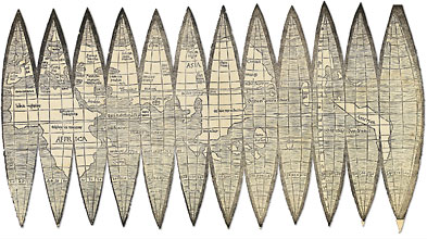
Photo Courtesy: Christie's
This world map by Martin Waldseemüller, the
first to use the word “America,” sold for more than $1 million
on June 8.
His globe gores turned out to be part of a set
of materials first published in 1507 by Martin Waldseemüller—a
German cleric, scholar, cosmographer, and cartographer— and several
assistants. In addition to the globe gores, they produced a large wall map
and a booklet describing the maps. Waldseemüller’s world map
was one of the first to include geographical features from the reports of
the explorers who sailed west from Europe after Columbus. He had examined
the accounts of Amerigo Vespucci’s voyages to South America between
1497 and 1504, and he used that information to draw the east coast
of the continent. He had no accounts of the geography beyond the Caribbean,
so the coasts of most of North and South America were pure guesswork. Waldseemüller
honored Vespucci’s discoveries by labeling the new continent America,
a name that stuck. The name was actually suggested by Waldeseemüller’s
assistant, Matthias Ringmann, who wrote the introduction to the map, called
the Cosmographiae Introductio: “There is a fourth quarter
of the world which Amerigo Vespucci has discovered and which for this reason
we can call ‘America’ or the land of Americo.” This
was the first use of the word “America” on any printed
document, and Waldseemüller’s use of it was l.ikewise its first
on any map.
There were, until our coffee-drinking collector
realized what he had, only three sets of the globe gores known to exist.
A number of copies of Cosmographiae survived, but the first gores
were not discovered until 1871. That map now resides in the James Ford Bell
Library at the University of Minnesota. The two other copies are in Germany,
one at the Bavarian State Library, and the other in a public library in
the small town of Offenbach, having been found bound into an unrelated library
book in 1992. The German collector’s map was put up for auction at
Christie’s in London and sold on June 8 for slightly more than a million
dollars (£545,600 or $1,002,267, including the auction premium), a
price just below the low estimate. The buyer was Charles Frodsham and Co.
Ltd., a London antique-clock dealer. The three other known copies are on
full sheets of paper, so the fact that this set was cut out undoubtedly
kept bidders from reaching deeper into their pockets.
The survival of maps in general seems to
be inversely correlated with size; the larger the map, the rarer it tends
to be. A good example of this is Waldseemüller’s wall map, which
measures eight feet by four feet. The Library of Congress purchased the
only known copy four years ago from a German collector. It survived because
its twelve separate sheets were bound into a portfolio that had been put
together by German globe maker Johannes Schöner. At some point, the
portfolio was acquired by the library of the Castle of Wolfegg, at Wurttenburg,
and was discovered in 1901 by a Jesuit historian, Josef Fischer. Luckily,
by this time the map was old enough to be recognized as valuable. Following
years of negotiation and diplomacy, the Library of Congress acquired the
map and an export license at a cost of $10 million.
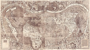
The Library of Congress paid $10 million for
this wall map by Waldseemüller.
Photo Courtesy: Library of congress
After such a high-profile purchase, made with $5
million appropriated by Congress and a matching amount raised from private
donors, some have questioned whether the map is actually a first printing
from 1507. The watermarks on the paper match another map more definitively
dated eight years later (indeed, Christie’s gave a 1515 date for the
Library of Congress map in its press materials). While there is no historical
evidence of a second printing of the wall map, it is not inconceivable that
the wood-block plates could have been reused at a later date. The question
is somewhat academic since the Library of Congress’s map is one of
a kind, but for collectors keen to own what has been called the “birth
certificate of America,” a later date for the wall map would mean
the globe gores are the sole surviving first appearance of the word “America” on
a map.
When I asked Dr. John Hébert, chief of the
Geography and Map Division at the Library of Congress, for his view, he
dismissed the later date as speculation and vigorously defended the 1507
date for the library’s wall map. He pointed out that the watermarks
are only on the descriptive text pasted onto the corners of the maps and
that the dating of the watermarks themselves is far from certain. This is
true. The dating of the watermarks is derived from the fact that they are
the same as those on another Waldseemüller world map, called the Carta
Marina, which has been more positively dated to 1515. The two maps could
have the same watermark simply because the printer had a lot of paper with
this watermark and used the same paper for both maps.
The watermark evidence from the globe gores adds
to the confusion. The four copies are printed on three different papers.
The watermarks on the globe gores sold at Christie’s and on the University
of Minnesota copy have been dated by some to 1526, not 1507, but that later
date is not certain either. All of which illustrates the difficulty dating
old maps, and the uncertainty likely contributed to a lower-than-estimated
auction result for the globe gores. The Library of Congress declined to
bid because of it, and others may have as well.
But what is the special appeal of the Waldseemüller
maps, other than simply being the first to name America? The answer lies
in a few other “firsts” claimed by the maps. They are the first
printed maps to depict a North American continent in the western Atlantic
and the first to show the New World as an entirely separate continent. They
are also the first maps to depict all of South America and the Pacific Ocean
beyond, or at least a separate ocean between Asia and America, an ocean
that was not physically discovered until 1513 by Vasco Núñez
de Balboa, when he crossed the Isthmus of Panama. The existence of the Americas
dispelled Christopher Columbus’s hope that there was an easy ocean
route to the riches of the East and the Spice Islands by sailing west from
Europe. As Ferdinand Magellan was to discover in 1519, getting around the
Americas required a long and arduous voyage. Emerging from the strait he
found at the tip of South America on an unusually peaceful day, he named
the ocean he found what it was not: the Pacific.
Map makers of the sixteenth and seventeenth centuries
usually had to work with incomplete information and often resorted to what
passed as logic to depict what they thought ought to be, and Waldseemüller’s
group, following Vespucci, thought that there ought to be another continent
before the coast of Asia was reached. It was probably little more than an
intuitive leap but they had the fortune to have guessed correctly. All other
maps up to that point either had shown America as an eastern extension of
Asia or had conveniently run the western edges off the maps, thus evading
the question.
Waldseemüller’s maps, with as many as
1,000 copies distributed, influenced many later cartographers, and had far-reaching
geographical implications. His map was the embodiment of such a revolutionary
new notion of the world that, on that basis alone, it certainly qualifies
as a landmark map. The fact that so few survive, whatever their actual dates,
virtually guaranteed that one offered for sale would produce a jaw-dropping
price.