Chasing the Moon’s Shadow
How Edmond Halley mapped the solar eclipse of 1715 By Jeffrey S. Murray Jeffrey S. Murray is a former senior archivist with Library and Archives Canada, Ottawa, Canada.
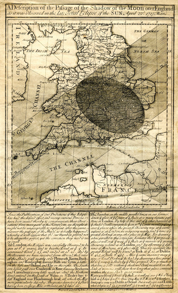
Thanks to a map painstakingly researched by Edmond Halley, Londoners were well prepared for the great solar eclipse of 1715. It was to be the first such astronomical event witnessed by the city in nearly 600 years, and Halley wanted to give the public advance warning so that the “suddain darkness … may give no surprise,” and they would be less likely “to look upon it as Ominous, and to Interpret it as a portending evill to our Sovereign Lord King George and His Government.” The map was printed on one side of a single-sheet, folio-size broadside and showed the route the moon’s shadow was expected to follow on its eleven-minute traverse of “ye whole Kingdom.” The lower part of the broadside described the event as a natural phenomenon of the motion of the moon—a subject that was dear to Halley’s heart because it was thought to hold the key to finding longitude.
Calculating a ship’s longitude at sea was a problem that had plagued mariners for centuries and had forced the British government into offering a princely £20,000 (about $6 million today) reward for anyone who found a practical solution. The coveted longitude prize was eventually awarded in 1773 to John Harrison for his marine chronometer. However, the lunar distant method—based in part on Halley’s research on moon and star placement—remained an economically viable, if less accurate, method of calculating longitude until the mid-nineteenth century.
The manual calculations leading up to Halley’s eclipse map must have been daunting even for a man of his scientific stature. Thirty-three years earlier he caught the scientific community’s attention when he used Newtonian planetary physics and historical records to prove that the comets seen by Londoners in 1531, 1607, and 1682 were one and the same, and it would return to view again in 1758, and every 76 years after that. For his work on comets, Halley was awarded a Doctor of Civil Law at Oxford and the comet was named in his honor posthumously.
Prior to Halley’s 1715 map, other cartographers had included views of solar eclipses on their maps, but they were little more than marginal decoration to the much larger geography that was the map’s focus, and were drawn at a scale that gave little detail on the area affected. What set Halley’s 1715 map apart from his contemporaries was his willingness to delineate the area on the ground that would be impacted by the moon’s shadow and the time when the event would be at its maximum darkness. He also came up with the idea of representing the moon’s path of total darkness as an easy-to-read dark strip that contains the oval-shaped umbra—an intuitive innovation that perfectly merged geographical space to a temporal dimension.
To accurately map the eclipse’s path, Halley had to take into account several complex factors: the movements of the Earth around the sun and the moon around the Earth, and the Earth’s rotation on its axis. In addition, he also had to have a base map with accurately marked longitudes and latitudes. Although new to London’s mapmaking scene, John Senex provided Halley with just such a map.
Senex started a small book publishing business when his apprenticeship with the bookseller Robert Clavell ended in 1702. One of his first titles was a translation from the Latin of Halley’s research on comets, a work that marked the beginning of a long-term relationship between the two. It eventually led to Senex forming a partnership with the well-established map publishers, Seller and Price. This new partnership led to the publication of a set of twenty maps that “in correctness, and all other particulars, far exceed any yet done,” and helped to cement Senex’s reputation as a leading London mapmaker.
It was no accident that Halley and Senex chose the broadside format to announce the upcoming eclipse. Broadsides had been around for more than two centuries, and were an effective method for presenting timely information on any number of subjects from the spectacular to the catastrophic, from the marvelous to the curious. The single sheet could be composed, engraved, and distributed in only a few days. For a copper-engraved broadside, the print run averaged around 2,000 copies, although larger printings are known, like Erasmus’ Adagia, which is thought to have gone through thirty-four editions of 1,000 copies each. The earliest known astronomical broadsheet describes the meteorite that fell on the Alsace village of Ensisheim in 1492. Over the next three and a half centuries, an estimated 4,000 to 5,000 titles were prepared. Regrettably, because of their ephemeral nature—they were meant to be consumed, then tossed—probably less than one percent survives today.
Distributing information on the eclipse more widely had obvious financial rewards. Despite its modest price of six pence, the broadside must have generated a nice income for both Halley and Senex. Although figures are not available, one of his competitors in the broadside business, William Whiston, admitted in his memoirs that he made £120 from his publications and lectures on the eclipse, an amount that “maintained me and my family for a whole year together.” Halley’s broadside no doubt also helped to improve his name recognition, which would have played no small part in other commercial ventures, and possibly in his appointment as Britain’s Astronomer Royal after John Flamsteed’s death in 1719.
Thanks to Halley’s promotional efforts, Britons turned out in high numbers to witness the 1715 event. Forever the consummate scientist, Halley could not resist taking advantage of the interest and asked “the curious … to Observe it … with all the care they can” and to report back to him so that “we may be enabled to Predict the like Appearances for ye future, to a greater degree of certainty than can be pretended to at present.”
As it turned out, Halley’s predictions were off slightly, as was pointed out to him by several observers who had relied on his map and unknowingly placed themselves outside the path of totality. Halley, on the other hand, had placed himself well within the path of maximum darkness and, “with a very good Telescope of about Six Foot,” watched the entire proceedings under a “perfect serene azure sky” from the Royal Society’s quarters at Crane Court, London.
Encouraged by the interest shown in his map and by all the on-the-spot observations sent to him, Halley issued a second edition of his broadside about five months later. His new map updated the path of totality to what was actually observed, shifting it eighteen miles to the south and adjusting the contact times by four minutes. To this new map, he also added his predictions on a second eclipse, one that would pass over London in May 1724. About two weeks before the second event, this map was also updated so as to include the path of the moon’s shadow as it passed over Ireland and France. This last update suggests Halley and Senex were attempting to extend interest in their maps to customers in lucrative markets overseas.
Although his name today is most readily associated with the comet that bears his name, Halley made considerable contributions to cartography. He was the first to map the earth’s magnetic field, the trade winds, hundreds of stars, and of course, the solar eclipse. The conventions he pioneered were unrivaled and are still used by cartographers more than three centuries later. For Halley, much of the natural world was “better expressed in the Mapp … than it can well be in words.”


