Pretty Polly
Charitable Birds from Graham Arader, Sotheby’s New York, $194,500
On June 19 Sotheby’s held a 200-lot sale of books, prints and pictures from the collection of W. Graham Arader III, whose presence has for decades been dominant in the marketplace for maps, colour-plate books and prints.
Arader’s glittering career has not always endeared him to trade colleagues, but for this stock clearance he generously offered to donate 20% of the hammer price to the purchaser’s nominated charity—a way of giving something back, said Arader, to the libraries, universities, foundations, botanical gardens, zoos, etc., that helped him in the past. The sale raised $3.26 million in all, which means a tidy sum for charity, but it could have been so very much more. Among unsold lots were many with high five- or six-figure estimates.
Top of the range natural history material, well represented in this sale, has in recent years seen prices falling well short of what was once possible, and a couple of famous parrot books serve as an example of this trend.
Handsomely bound and containing 145 etched, colour-printed and hand- finished plates, Levaillant’s Histoire naturelle des perroquets of 1801-05, exceeded the high estimate in selling at $194,500. While that makes it the most expensive copy sold this decade, one has to go back to 1989 to find the record-holder: the copy from Bradley Martin’s superb ornithological library sold at $231,000.
Recent saleroom form can be a damper on any lot’s chances, and a copy of Edward Lear’ famous 1830-32 work on Parrots, acquired in 2003 at Christie’s in London for £50,000, failed to sell against a low estimate $125,000. Again, the Bradley Martin copies that sold 20 years ago for $231,000 and $209,000, remain the benchmark.
Washington Slept Here
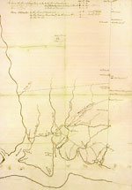
18th-Century Map of Mount Vernon and environs, Christie’s New York, $116,500
In the beginning, America’s best-known home was represented only as a small, carefully inked rectangle facing the Potomac, on a map drawn up by the Culpeper County Surveyor, aka George Washington. Washington’s 18- x 13-inch “Sketch of the Roads & Country between Little Hunting Creek and Colchester” included the 2,560-acre Mount Vernon estate he inherited from his half-brother, Lawrence.
Doubtless Washington cherished hopes that one day the boundaries of his estate would encompass the original 5,000-acre tract that had been granted to Colonel Nicholas Spencer and Lt. Colonel John Washington in the 1670s. Between 1757 and 1786 Washington managed to add some 5,600 acres, mainly by purchasing adjacent tracts, but all one can say about the age of this map, sold on June 24, is that it must pre-date 1769, as it still shows the 200-acre homestead of Captain Joseph Posey, east of Mount Vernon, purchased by Washington that year.
Tell Ptolemy
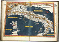
15th Century Atlas, Sotheby’s London, $1,022,130
Probably the first printed atlas to include new maps, and the first printed outside Italy, the 1482 printing at Ulm, in Southern Germany, of Ptolemy’s Geographia, was an extraordinarily ambitious production for the 15th century.
Two earlier printed editions had contained only maps based on descriptions of the world provided in the 2nd century AD by Ptolemy, but the 32 woodcut maps in the Ulm edition, all but one of them double-page, introduced new maps of Spain, Italy, France, Palestine and Scandinavia—the latter including Iceland and Greenland, which also appear for the first time on a world map. A 1482 Florence edition also included the new maps, but priority would seem to be uncertain.
The maps in all 15th-century editions are based on work by Donnus Nicolaus, a Benedictine of Breslau who in the 1460s and ’70s prepared a series of magnificent vellum atlases in Florence. These were presented to various dignitaries and the model for the printed Ulm edition was one presented to Pope Paul II. That original papal manuscript would appear to have been taken from Rome to Ulm for copying by the printer, Lienhart Holle, but never returned, as it is now preserved at Schloss Wolfegg in southern Germany.
Printing costs almost ruined Holle, and at one point the Duke of Milan wrote to the Council of Ulm on behalf of Milanese paper merchants, who were still owed very large sums for paper supplied. That a large number of the surviving copies have an Italian provenance may indicate that Holle tried to pay off his debts in kind.
Even the incomparable Wardington atlas collection, which in 2006 saw £1.9m paid for a copy of the very first printed atlas, the 1477 Bologna edition of the Geographia, did not contain a copy of the first Ulm edition. This example had full contemporary colour throughout and Sotheby’s map specialist, Cathy Slowther, feels that even at £623,250 ($1,022,130) the buyer may have had a bargain.


 Ian McKay’s weekly column in Antiques Trade Gazette has been running for more than 30 years.

