 Ian McKay’s weekly column in Antiques Trade Gazette has been running for more than 30 years.
 All Over the Map
This month’s broad selection includes maps, first editions of sporting books, a rare movie poster, a comic book, a NASA flight plan, and more!
Blaeu Unveils the Dutch Navigators
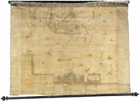
Nova archipelagi orientalis tabula. A. 1663, by Johannes Blaeu, Swedish Krona 2.82 million ($412,030) at Stockholms Auktionsverket on December 16.
One can see why the saleroom might have had doubts about this rare wall map, for even a digital image shows that sections of the text and the map are flaking away or already missing from the woven cloth on which it has been mounted. That didn’t deter bids well past the estimate of around $750.
In the absence of any imprint, the saleroom suggested in a very brief catalogue entry that it may have been issued in Amsterdam, c.1670, but with some help, I eventually found my way to map 80 in Günter Schilder’s Australia Unveiled: The Share of the Dutch Navigators in the Discovery of Australia (1976)—where almost all was revealed.
Illustrated there was what appeared to be the very same map, albeit lacking the added title banner found on the Stockholm version and titled instead Archipelagus Orientalis sive Asiaticus. Of this map, Schilder writes, “In the ‘Atlas of the Great Elector’ in the Deutsche Staatsbibliothek, Berlin...[is] preserved, possibly the best general map of Dutch sea power in South East Asia executed in the 17th century. It contains all Dutch discoveries in Australia and those in Tasmania and New Zealand of Tasman’s first voyage.”
Printed by Blaeu in Amsterdam in 1659, that Berlin map is framed on three sides by text in Latin, Dutch, and French (the Swedish catalogue refers only to Dutch text in its version), and Schilder quotes from Blaeu’s own words:
“Papas landt or Nova Guinea, Nova Hollandia, discovered in the year 1644, Nova Zeelandia or New Zealand reached in 1642, Antoni van Diemens land found in the same year, Carpentaria, thus named after General Carpentier, and still other lands, partly discovered, are shown on this map. But of all these and of the above-mentioned islands we cannot speak more fully because of the want of space; nor has there yet been published anything, or but little concerning these last named; wherefor the reader and spectator must rest content with this map, until I, Blaeu shall publish concerning these and all the aforesaid a large book, full of maps and descriptions, which is at present being prepared.”
Schilder tells us that the book to which Blaeu refers was never published and observes that it is curious that what is probably the most important map of the Dutch East Indies in the seventeenth century has received so little attention.
It has now. This previously unknown, second edition copy of 1663 was bought on behalf of a client by Filip Devroe of leading Belgian map dealers, Sanderus of Ghent.


